Filtered by:
- Category
4 items
- List
- Grid
This auctioneer has chosen to not publish their results. Please contact them directly for any enquiries.
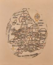

Lot 18
Mary Maule (18th-19th Century) British. Map of England, Tapestry dated 1786, In a darkwood frame,
Mary Maule (18th-19th Century) British. Map of England, Tapestry dated 1786, In a darkwood frame, Oval 15.5" x 12.5" (38.4 x 31.8cm) and a compani...
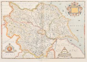
Lot 19
Emery Walker Limited (20th Century). A Collection of Sexton's Atlas of England and Wales (not
Emery Walker Limited (20th Century). A Collection of Sexton's Atlas of England and Wales (not complete), with index, primary tables and frontispie...

Lot 20
Tobias Conrad Lotter (1717-1777) German. "Planisphaerium Coeleste", Map published by Aug. Vindel,
Tobias Conrad Lotter (1717-1777) German. "Planisphaerium Coeleste", Map published by Aug. Vindel, unframed 18.75" x 22.25" (47.6 x 56.5cm)
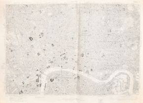
Lot 21
20th Century English School. "Map of London" edition of 1920, Sheet K, Map, Published by Ordnance
20th Century English School. "Map of London" edition of 1920, Sheet K, Map, Published by Ordnance Survey Office, unframed, 24" x 36" (61 x 91.5cm)